Präsentation herunterladen
Die Präsentation wird geladen. Bitte warten

1
Mapbender Workshop Astrid Emde Christoph Baudson FOSS4G Barcelona 2010

2
Christoph Baudson Mapbender Developer Team Project Chair
PSC (Project Steering Commitee) WhereGroup Bonn
 WhereGroup Bonn")
3
Astrid Emde Mapbender Developer Team PSC (Project Steering Commitee)
WhereGroup Bonn FOSSGIS e.V. Anual FOSSGIS conference German technical translation of the book Web Mapping Illustrated

4
Mapbender Workshop Structure
Introduction to Mapbender - 30 min Hands on min Outlook – 45 min Questions & answers – 15 min

5
What does Mapbender do? Create geospatial web applications without writing a single line of code Create and maintain an OWS repository (focus on WMS, WFS) Distribute configured services among applications Grant users and user groups access to applications and services
 Distribute configured services among applications. Grant users and user groups access to applications and services.")
6
Architecture diagram CB – Client Server ...

7
The Mapbender components
OGC Web Services Applications User and groups

8
Mapbender History 2001 project started in at CCGIS (Bonn, Germany) with the name CCGIS Client Suite optimized for SICAD SD-IMS using WMS standards 2003 GNU GPL License, the name Mapbender was invented, registration on sourceforge.net 2005 using CVS on sourceforge.net 2006 Mapbender passed incubation and is the first official OSGeo project from 2008 Mapbender takes part at Google Summer of Code 2009 jQuery, Mapbender API Mapbender History

9
Project Organisation OSGeo Project https://mapbender.osgeo.org
Mapbender user map Wiki Trac SVN mailing-lists IRC-Treffen irc://irc.freenode.net#mapbender regular development meetings, Fairs, OSGeo

10
Software Requirements
Web Server (Apache) PHP > 5.1.x Administrative Database PostgreSQL (PostGIS) MySQL Browser Mozilla Firefox Internet Explorer gettext, ImageMagick
 PHP > 5.1.x. Administrative Database. PostgreSQL (PostGIS) MySQL. Browser. Mozilla Firefox. Internet Explorer. gettext, ImageMagick.")
11
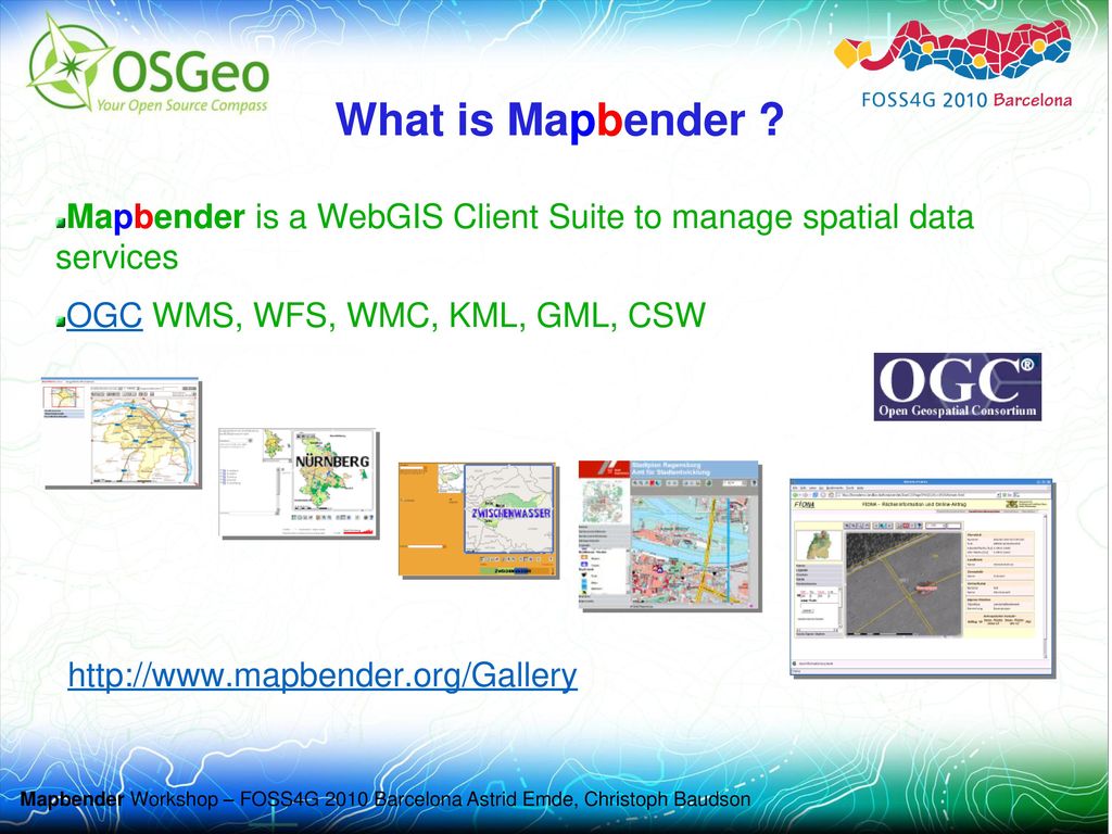
What is Mapbender ? Mapbender is a WebGIS Client Suite to manage spatial data services OGC WMS, WFS, WMC, KML, GML, CSW
12
What is Mapbender ? CAT GeoRSS DB WMS Dateien Mapbender DB DB WMS
neu in 2.7 GeoRSS neu in 2.7 DB WMS Dateien Mapbender DB DB WMS Dateien WMC WFS WMS DB

13
Mapbender Demos Aktuelle Projekte Münster,

14
Mapbender in Geoportal solutions
Geoportal.RLP PortalU GeoPort.HRO Geoportal der Stadt Remscheid Geoportal Wohnregion Bonn-Rhein-Sieg Geonetzwerk Münsterland

15
Mapbender as a city portal
GeoPort.HRO Geoportal der Stadt Remscheid Stadtplandienst Mainz Stadtplandienst Regensburg Portal der Gemeinde Zwischenwasser Stadtplandienst Nürnberg

16
More Mapbender Solutions
Tourenplaner RLP Naturpark-Scout FIONA - Flächeninformation und Online-Antrag FLOrlp Landesarchiv Baden-Württemberg Find more Mapbender solutions in the gallery

17
What offers Mapbender ? HTML, JavaScript, PHP, AJAX, (Geo)JSON, jQuery
Administrationsdatenbank: PostgreSQL Modulare Organisation des Quellcodes Mapbender API Möglichkeit des Aufbaus individueller Applikationen über HTML-Elemente Nutzung von jQuery Elementen, Themeroller Internationalisierung über .po und .mo-Dateien

18
The WhereGroup Bonn, Germany http://wwww.wheregroup.com
founded in january 2007 as merger of CCGIS, KARTA.GO GmbH and Geo-Consortium 15 employees service provider with experience in all field of spatial data management with free software: WebGIS, SDI, database , relevant standards, trainings, conferences founder member of the FOSS Academy member of the OGC Open Source-projects: Mapbender, PostNAS

19
WhereGroup Projects Survey Office of Rhineland-Palatinate GeoPortal.rlp Survey Office of Baden-Württemberg: Geodatenportal Pollutant Release and Transfer Register German Hiking Association: Webbased Hiking Trail Administration Agency for Tourism of Rhineland-Palatinate: Cycle Route Planner for of Rhineland-Palatinate Archaeological Office of East Friesland

20
Was ? PDF-Druck DIN A4 bis DIN A0 / gedrehter Druck Securitymanagement
Zugang zu sicheren Diensten durch die OWS Proxy Funktionalität für WMS und WFS Leichte Einbindung in ein CMS Erweiterungsmöglichkeit um eigene Module Zugriffsprotokollierung ermöglicht Anbindung an ein Abrechnungssystem

21
Was bietet Mapbender ? Mapbender stellt Template-Applikationen (GUI) bereit Applikationen zur Administration und Konfiguration der OWS Dienste sowie von Benutzern und Gruppen Applikationen zur Darstellung und Abfrage von OGC WMS Diensten Web-basierte Digitalisieroberfläche über WFS-T Suchfunktionalität über WFS, Metadaten oder SQL OGC WMC Handling (Web Map Context Dokument)
")
22
Was bietet Mapbender ? Erweitertes WMS Monitoring
Install- und Update-Skript Erweiterte WFS Konfiguration (Datumsfelder, Hilfetexte, Checkboxen), WFS Trefferausgabe in ResultList Erweitertes WMC Handling mit Export nach OpenLayers WMS mit HTTP basic und digest Authentication Neuerungen in Mapbender 2.7
, WFS Trefferausgabe in ResultList. Erweitertes WMC Handling mit Export nach OpenLayers. WMS mit HTTP basic und digest Authentication. Neuerungen in Mapbender 2.7.")
23
Was bietet Mapbender ? Navigation ohne Buttons WFS 1.1.0
Erweiterte Digitalisierung (Teilung, Fusion, En-/Exklaven, Linie verlängern, Objekt Duplizieren)
")
24
Try Mapbender on your own

25
Thanks you for your attention!
If you have any question please contact us Astrid Emde Christoph Baudson or write to the mapbender-users mailinglist

26
Christoph Baudson 2 Folien
Mapbender Developer Team Project Chair PSC (Project Steering Commitee) jalfglkadsjfl Astrid Emde WhereGroup Bonn
 jalfglkadsjfl. Astrid Emde. WhereGroup Bonn")
Ähnliche Präsentationen


 Frank Klaproth The Academic Subject.>")


 e.V. www.barrierefrei- kommunizieren.de Blended Learning for people with disabilities.>")


